Old Dalton High Ranked Highest in Site Assessment By Sabrina Damms, iBerkshires Staff
12:45PM / Tuesday, April 22, 2025 | |
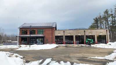
 The empty lot next to the Senior Center ranked highest of four possible locations for a new Dalton police station. The empty lot next to the Senior Center ranked highest of four possible locations for a new Dalton police station. |
DALTON, Mass. — The lot next to the Senior Center, the old Dalton High, is a viable location out of the four assessed for the proposed police facility, but it's not without challenges.
The site assessment by Brian Humes, owner of Jacunski Humes Architects LLC of Berlin, Conn., showed that the lot had the highest ranking of the four submitted for study.
"This is a first introduction into what we've looked at, how we've looked at it, how we come about with our recommendations, and then a further conversation as to whether this satisfies your site investigations, or whether you feel we need to do something further with these site recommendations," Humes said.
The board can also decide whether they want Humes to assess another property.
Although the town has not made a decision yet, it will eventually select a site for Humes to apply a schematic design solution.
"That's getting ahead, because we're not at that point yet but whatever site you instruct me to now go further with, I will be able to draw floor plans, draw site plans, and those would all be specific to the site that you then say is the recommended site," he said.
Humes emphasized that the assessment has limitations. He noted that his work was restricted to the four sites provided by the Public Safety Advisory Committee.
Additionally, no geotechnical borings or subsurface investigations were conducted. However, he did consider information from existing engineering reports.
The goal of the site assessment is to identify the site that best meets the Police Department's needs, based on call volume, state requirements, and other factors.
In his presentation, Humes did not disclose the specific locations of sites one, two, and three because they are privately owned and wanted to avoid influencing potential negotiations with private property owners.
He assessed the sites on a 100-point scale, using 13 key criteria that he had developed. These criteria included: acquisition costs, lot size in relation to site needs, parking availability, construction and development expenses, location and accessibility, traffic patterns, vehicular access and egress, availability of utilities, visibility, neighborhood impact, zoning restrictions, considerations for wetlands and floodplains, and the convenience of development.
The property was ranked 85 out of 100, but would have been in the 90s if it were not for the upstream flooding from Walker Brook, Humes said.
If the town were to select this property, voters would first have to approve changing the lot designation at a town meeting.
When voters approved the demolition of the high school, it included repurposing the lot for housing.
However, the site is owned by the town, so it would not have to pay for its acquisition.
Humes recommended that the town pursue flood mitigation strategies, which have already been outlined for the Walker Brook project, which would benefit municipal developments, including the Senior Center and adjacent residential properties.
"I think you need to have that conversation, or understand that conversation when you're talking about whether further municipal development is going to happen on this site," he said.
It's not an issue with groundwater; it's an issue with surface water, he said.
The lot is not technically in a floodplain, but has had flooding caused by an undersized culvert, especially during severe weather events like Hurricane Irene, he said.
"As far as convenience, it's a beautiful site. It's level. It has very little [zoning] restrictions. It could improve a municipal presence on this site. There has been a much larger municipal presence on this site, being the high school that had been removed," Humes said.
"It has little impact as far as getting a contractor on this site, having the ability to build, having the ability to develop the site without impacts to things around it, and I found it a very convenient location."
During previous conversations surrounding the Walker Brook project, it was unclear if the level of improvement to the culvert was actually necessary, given its projected cost estimate of over $5 million, said Select Board member Dan Esko.
"I believe we were trying to go for a grant that would help us do that, but at the cost of 5 million, when you look at the cost-benefit, it's a whole 'nother conversation," Esko said.
"We would have to foot that entire bill [because] that grants is not available because we're not actually in a floodplain. We needed to prove, I think, a certain monetary amount of damages, potential damages, from a flood event, that we were not able to meet that threshold."
The town could merge the two problems, the Walker Brook flooding and the need for a police facility, together to "find one great solution" and get grants for the different problems, said Don Davis, co-chair of the Public Safety Advisory Committee.
The flooding does not eliminate the site from consideration; it still has very good potential, Humes said.
He highlighted that the town can construct the facility by designing the building with flood-resistant techniques, such as raising the finished floor elevation and elevating the building out of the lowest elevation.
Another obstacle the town would have to navigate is the inaccurate perception that residential areas have when a police station is proposed to be built in their area, such as perceived disruption and increased traffic and activity, Humes said.
Based on Humes' previous experiences with similar projects, police facilities can be good neighbors. He demonstrated that, unlike other emergency facilities, calls are not answered directly by the police station, and the level of activity at the building is not as high as most residents believe.
In fact, police facilities can provide a "security blanket" for neighborhoods, potentially reducing crime in the area, he said.
Other Sites Assessed:
The first site received a score of 69 out of 100. The property has 2.7 acres, is visible, has easy access to public transportation, and there are minor zoning restrictions.
However, its unique shape presents challenges. The lot also has a projected high acquisition cost, Humes said.
There are existing features on the site that may need to be removed which increases the cost of construction, he said.
"The unique configuration of this site means that there would be more of an impact to neighborhood residential properties, and we would have to develop that pretty close to other residential properties just because of the configuration of the site, the location of the site," Humes said.
The second site received a score of 48 out of 100, is on a public transportation route, and is visible.
The property has 3.3 acres and had a lot of challenges, which were related to the existing uses of the site. The entire 3.3 acres was not all available for development, Humes said.
It is private property, so the town would have to pay to acquire it and would have to overcome several regulatory issues, he said.
Additionally, it had limited parking availability, and the town would need to find a way to get two points of egress and access points from the site.
The third property received the lowest score of 51 out of 100 and was the smallest site assessed at 1.28 acres.
It had very limited development potential, had narrow frontage, and would require a multi-story building.
|